
Letting Go of Paradise
Three years after Superstorm Sandy slammed into New Jersey’s coast, few local communities want to accept that the Shore’s glory days are numbered.
Article body copy
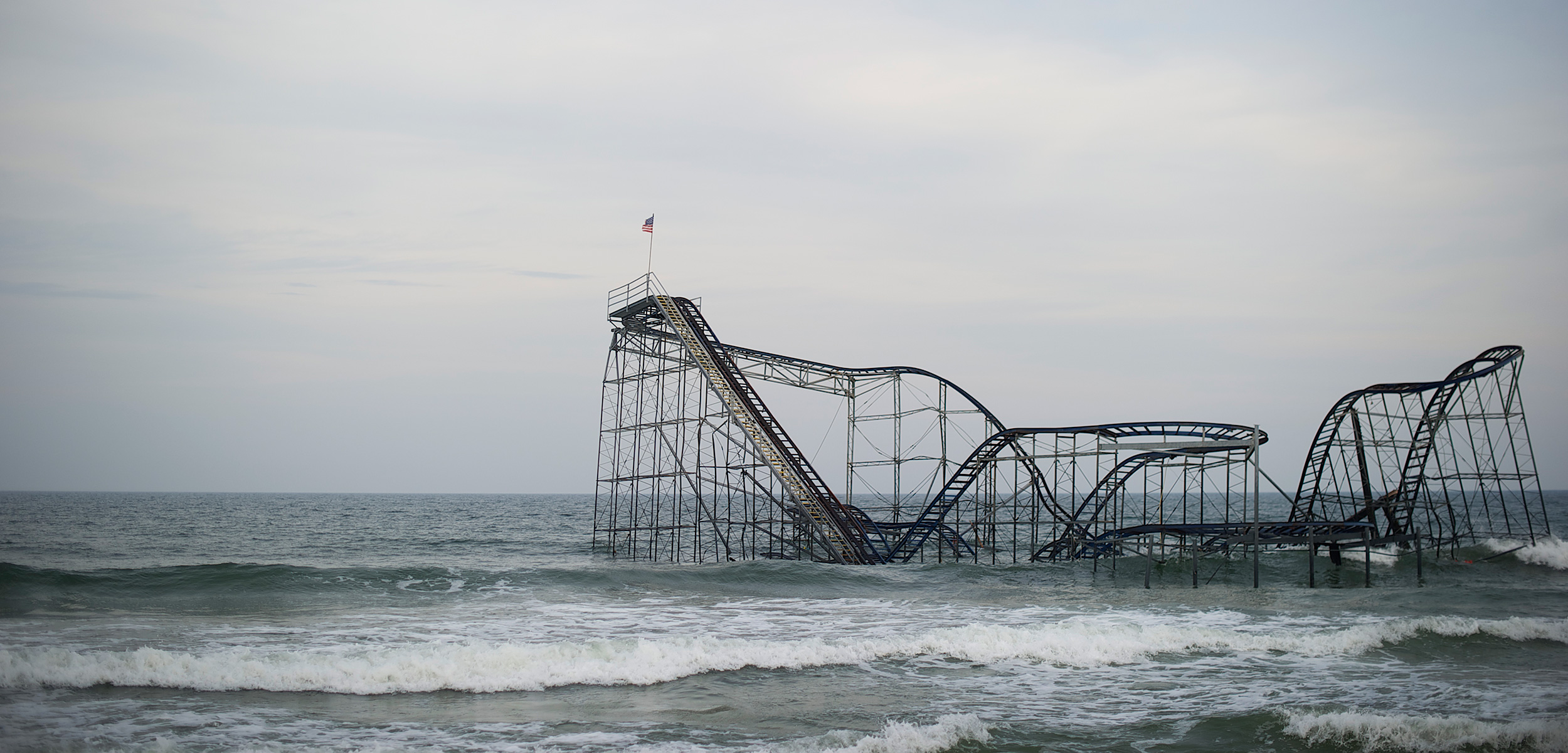
The Jet Star roller coaster was never the best amusement park ride around, but just before riders plunged down the steep decline from the steel coaster’s tallest trackway, a splendid, if brief, view of the Jersey Shore appeared, the coast stretching north and south into the distance. The seldom-seen aerial vista of open ocean abutting pancake-flat barrier island, separated only by a narrow margin of surf and beach, emphasized the precariousness of the water’s-edge resort area that typically draws tens of millions of sun-worshipping visitors every summer.
Then came the precipitous drop.
The Jet Star itself dropped into the Atlantic Ocean in October 2012 when Superstorm Sandy (aka Hurricane Sandy) hit the coastline and smashed the seaward end of Casino Pier, landing the coaster’s twisted carcass in the wind-tossed waves, and its forlorn, then infamous, image on television newscasts and Internet sites worldwide.
Superstorm Sandy was a huge, slow-moving tropical storm-cum-temperate zone cyclone that was packing hurricane force winds by the time it struck 24 states that fall. Sandy wrought US $50- to $70-billion in damage, making it one of the costliest hurricanes in US history. The storm’s massive onslaught damaged communities up and down the Jersey Shore—the 227 kilometers of coastline that stretches southward from New York Harbor. It also wounded the psyches of many survivors.
The mere threat of Hurricane Joaquin’s arrival several weeks ago, for example, sent Jersey Shore inhabitants into a tizzy of trepidation. Everybody—from seasonal beach people and water sports enthusiasts to the Shore’s million or so year-round residents and retirees—are starting to realize that it’s only a matter of time before the ocean rises again to inundate the coast. And some, but not enough, are starting to grasp the fact that a “Sandy II” would mark the beginning of the end of an enduring and treasured lifestyle, that is today an increasingly risky one, built—literally—on the shifting sands of barrier islands.
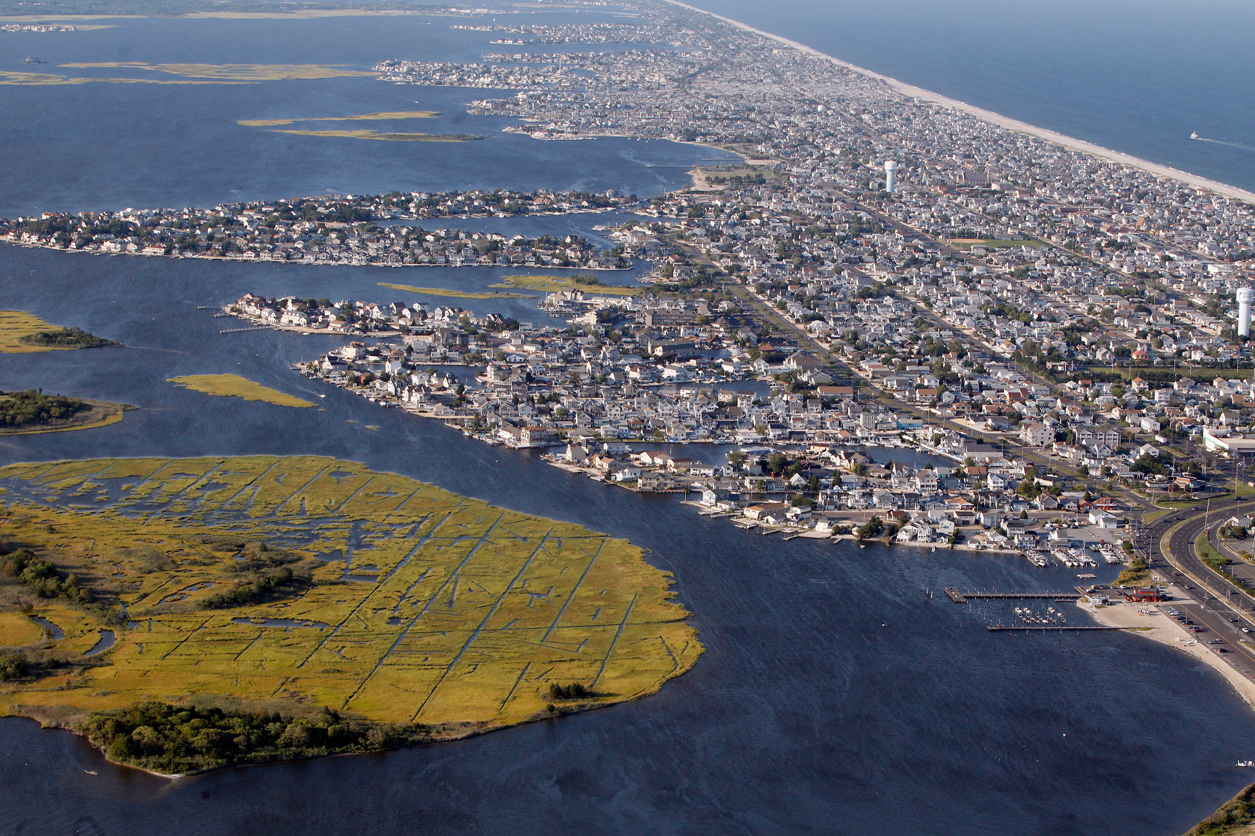
Barrier island beaches are what make the Jersey Shore so appealing to people. To own a piece of a barrier island on the Jersey Shore is like owning a piece of the Atlantic Ocean. Lounge on any porch of a house near the Seaside Heights boardwalk and the sound of the sea is often audible: on one side the ocean laps the white-sand shore, while no more than 1,000 meters in the opposite direction is the shoreline of a bay, in this case Barnegat Bay, a placid, shallow body of brackish water and pleasure boats that separates the barrier island from the mainland. Put simply, it’s a very nice place.
Barrier islands are rather common; some 2,150 of them front more than 10 percent of the world’s continental coastlines, scientists estimate. On the east and south coast of the United States, for instance, chains of barrier islands—405 of them—string from New York’s Long Island all the way down to South Padre Island, Texas, right at the Mexican border.
New Jersey capitalized on its barrier islands early on. Ever since the 1870s, when Atlantic City built its celebrated boardwalk, the Jersey Shore has been a popular vacation spot, a lure for leisure seekers from the mid-Atlantic states to as far north as Quebec and Ontario. Many know it as the place where revelers aired their tawdry laundry on the eponymous MTV reality show that played out a couple of years ago. Today’s bustling beach resort supports a tourist industry that rakes in as much as $10-billion each summer when the populations of the coastal towns along the Shore swell.
Beyond its economic and recreational value, the Shore’s ecological utility as crucial natural habitat and the coastal protection it provides are hard to overstate, although it may be difficult to see amidst the clutter of human occupation. The view from the roller coaster clearly highlighted the dense habitation of these slender bands of sand. But these overgrown sandbars are also the only physical buffer between the ocean and the shallow back bays behind. This is a problem.
Nowadays, more and more Jersey Shore homes sit two meters off the sandy ground. The structures having been raised onto pilings to protect them from floods: Superstorm Sandy-size floods.
But here, on the third anniversary of the storm’s onset, many houses remain empty, with repairs incomplete. The recovery process has been painfully slow as homeowners fight for loans from the US Federal Emergency Management Agency while also awaiting renovation of the municipal infrastructure—roads, power lines, and so forth. The mending process is, however, at last nearing completion.
Yet, likely as it is that a Sandy II will unravel the restoration of this beach paradise, the timing is unknowable, which undercuts the immediacy of any such warning. Sandy II could hit tomorrow, or it could wait 30 years or more.
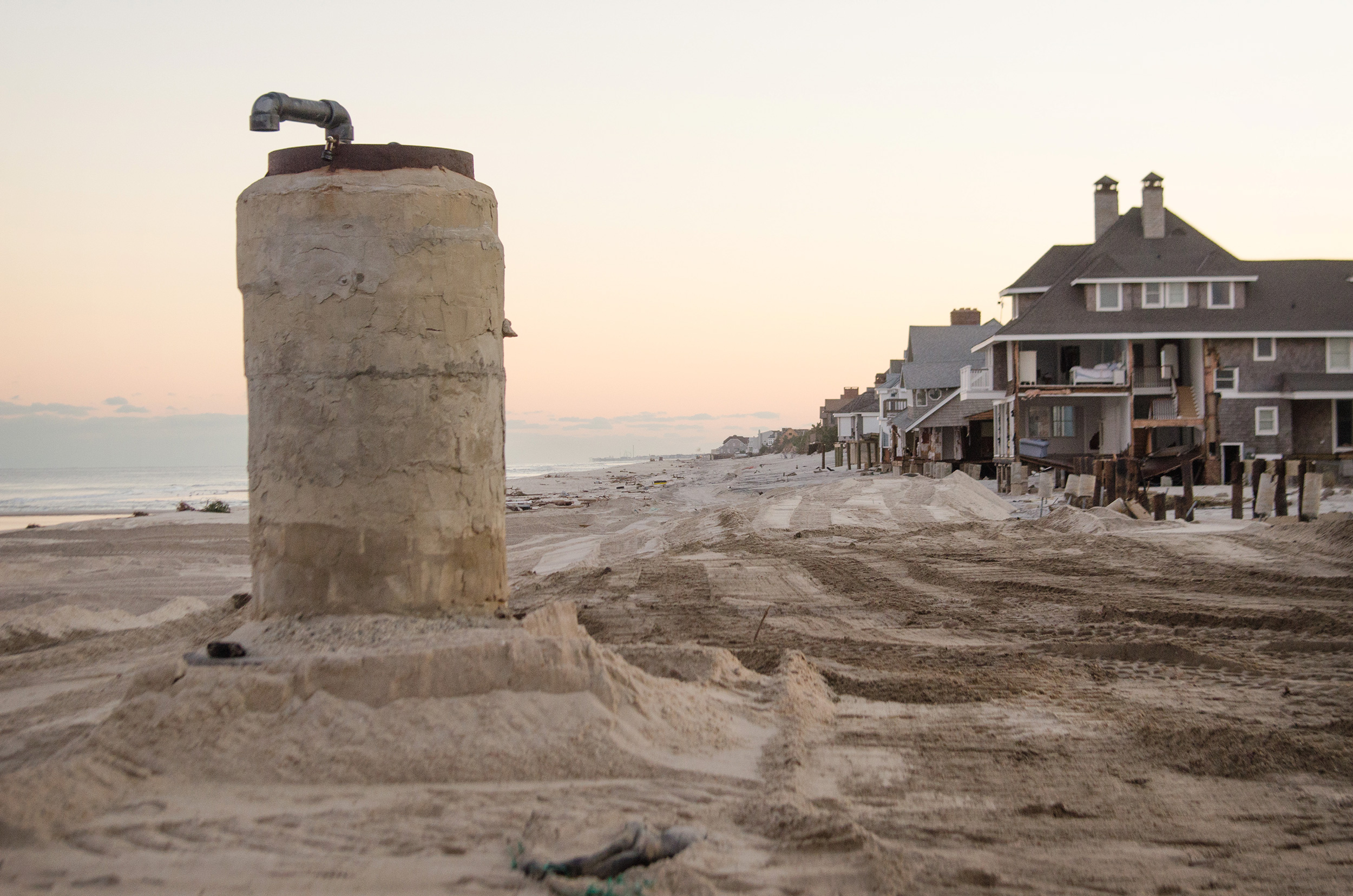
In the wealthy community of Mantoloking, the storm swept away the dunes. A standing drainpipe reveals how much sand the hurricane seized. Photo by Liz Roll/FEMA
The last big hurricane before Sandy arrived a half-century ago. The disastrous Ash Wednesday storm of March 1962 was an enormous mid-Atlantic nor’easter—an often-fearsome winter storm that blows from the northeast. The slow-moving storm, which flooded Long Beach Island just to the south of where Sandy made landfall, was the worst to strike the Shore in living memory.
But few locals knew of, or remembered, that last big blow because it occurred long before their time on the Jersey Shore. They could not imagine nor anticipate Sandy’s huge impact.
“It’s understandable; not that surprising,” says Mark Mauriello, a geologist, former commissioner of the New Jersey Department of Environmental Protection, and a Jersey Shore resident. “People didn’t expect Sandy because it was beyond most people’s experience. And most people are here only very seasonally in the summer.”
In the northeastern United States, really big storms are less common during summer months. Hurricane season is in the autumn, followed by strong winter nor’easters and other storms that typically scour sand from the shore, thinning the beach until calmer springtime currents replenish them, usually in time for the summer season when most people return to the Jersey Shore. Plus, from the 1960s to the 1990s, the North Atlantic experienced what scientists call a “hurricane drought” because of certain atmospheric and oceanic factors. Scary storms dropped out of the collective memory while property development accelerated.
Now, the big storms are back and given scientists’ assertions of inexorable sea level rise, the growing political resistance to costly government-funded disaster-recovery programs, and the increasing hesitance in the insurance industry to offer affordable coastal flood and wind damage coverage, a Sandy II will probably instigate a crisis along the developed US coast. Understandably, many taxpayers ask: why continue to fund the regular restorations of barrier island beach communities?
The time may have arrived to just let barrier islands be barrier islands.
To get a Sandy II reality check is easy, just ask basic questions about how barrier islands come to exist in the first place. “Barrier islands are nature’s way of straightening out irregular shorelines,” says Orrin Pilkey, a retired coastal geologist at Duke University and founder of the Program for the Study of Developed Shorelines at Western Carolina University. Since the big melt at the end of the last Ice Age, about 20,000 years ago, sea levels have risen 135 meters, with the shoreline advancing many kilometers up the slope of the East Coast continental shelf, he explains.
About 2,500 years ago, the sea levels stabilized and steady wave action and erosion sculpted the long strings of barrier islands along the East Coast. Behind the islands, flooded river valleys and low areas became shallow bays bordered by estuaries and salt marshes, like Barnegat Bay.
“Barrier islands are a very dynamic feature,” Pilkey says. To a geologist working with million-year time frames, barrier islands are entirely ephemeral, fleeting accumulations of sand coaxed into formation by the whims of ocean currents. They grow; they erode. And in time, they wash away.
A severe storm can slice a barrier island in half or scour away a wide swath of beach that for decades had stretched between homes and the sea. Prime beachfront property one day might be awash in ocean the next. The East Coast barrier islands are migrating inland sand grain by sand grain, Pilkey continues. “If you drill down into a beach for a soil sample, you’re apt to find peat from old salt marshes that the sand dunes overtopped years before,” he says.
Add steady, even accelerating, sea level rise to the mix and things get even grimmer. Norb Psuty, a geologist-geomorphologist and emeritus professor at Rutgers University, reports that during the past few decades the Atlantic Ocean has risen about eight centimeters every 18 to 20 years.
In addition, the previous pattern of natural beach replenishment has changed. No longer is it just a matter of winter storms carrying away sand and summer waves replacing it. The so-called “hardening” of the shoreline—that is, installing “hard structures” to armor and retain beaches—has backfired big time. It turns out that building groins, jetties, revetments, bulkheads, storm surge barriers, sea walls, levees, floodwalls, and the like—engineering methods that were often first adopted along the Jersey Shore—interfere with the natural alongshore movement of sand on the coastline.
“Little new sediment is being delivered to the system, so sand has become a diminishing resource,” Psuty says. “Storms send it offshore and it never comes back.”
By using hard structures to attempt to halt the erosion and eventual retreat of the barrier islands into the shallow bays behind them, less sediment and sand actually arrives from the adjacent beaches, meaning that everybody’s beach is saddled with a reduced sand budget.
“The policies that we now have in place to harden the beaches, the result of what I call the ‘New Jerseyization’ of the beaches all along the East Coast, will lead to the destruction of the beaches for the next generation. The real problem is that we haven’t learned from the problems that we first caused in New Jersey,” says Pilkey. The Shore is valuable, but by trying to preserve its shifting sands amid the ever-active ocean, the Garden State has merely been driving nail after nail into its own coffin.
A prime example of the New Jerseyization of the shoreline. Photo by Andy Mills/Star Ledger/Corbis
Clearly, the densely populated barrier islands are doomed in the long run, but exactly how long will the race extend before it’s truly bye-bye beach? “My colleagues and I think that within 30 or 40 years we’re going to lose most of our beaches because of widespread construction of sea walls and other hard structures,” Pilkey warns. “The developed shorelines along the East Coast will each have a little bitty beach at low tide and that’s about it.”
To understand why another Sandy will be poison to today’s beaches, consider what the first one actually did. That fall, the National Hurricane Center forecast that storm surges—wind-driven inundations of water—from 1 to 2.5 meters would arrive during high tide. Everybody on the Shore knew they were at risk, but no one understood that Sandy was a slow-moving storm whose strong winds would push the storm surge through the inlets between the barrier islands into the shallow back bays and keep the water there. In some areas, the floodwaters were two to three meters high.
According to US government scientists water surface elevation and flow data as well as storm track and weather conditions from the National Oceanic and Atmospheric Administration, Sandy’s surge seems to have forced seawater into Barnegat Bay through its two southernmost inlets. As the bulge of water traveled northward it flooded the bayside coastlines of both the mainland and the back side of the barrier islands. In the low-lying back bay streets of the islands, the overflow washed across toward the ocean side, flooding houses along the way. When the winds shifted and the offshore water level dropped, the water then ebbed back into the bay, and eventually out the inlets back into the ocean. Surprisingly, the oceanfront houses remained mostly untouched primarily because the dunes—which many communities had regularly replenished with sand and outfitted with storm fences and sand-grabbing dune grass—managed to hold off the massive assault of the ocean waves and high tide.
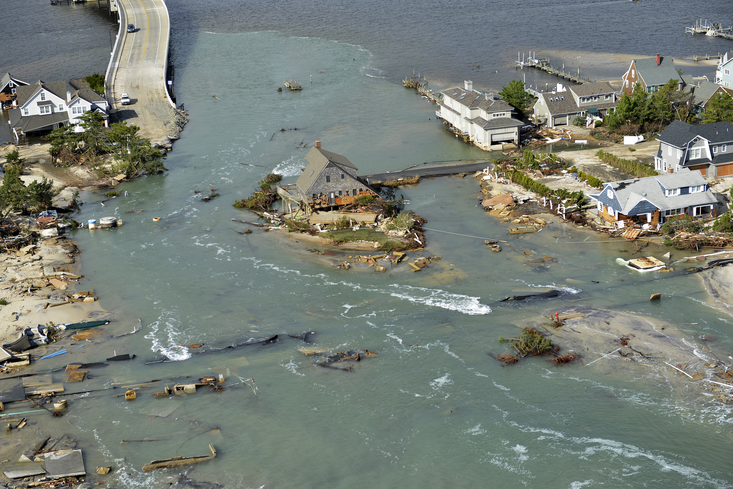
But the frontal dunes didn’t withstand Sandy everywhere along the coast. At a nearby coastal community called Ortley Beach, a strong backbay storm surge and huge oceanfront storm waves combined to undermine and overtop the dunes. A swift-running, tide-driven breach formed through Ortley Beach, leaving as many as 1,000 homes tossed around like so many Monopoly game pieces. Meanwhile, a few kilometers north of Ortley, in the affluent beach town of Mantoloking, three tidal breaches swamped one of the island’s two access bridges to the mainland, along with hundreds of houses.
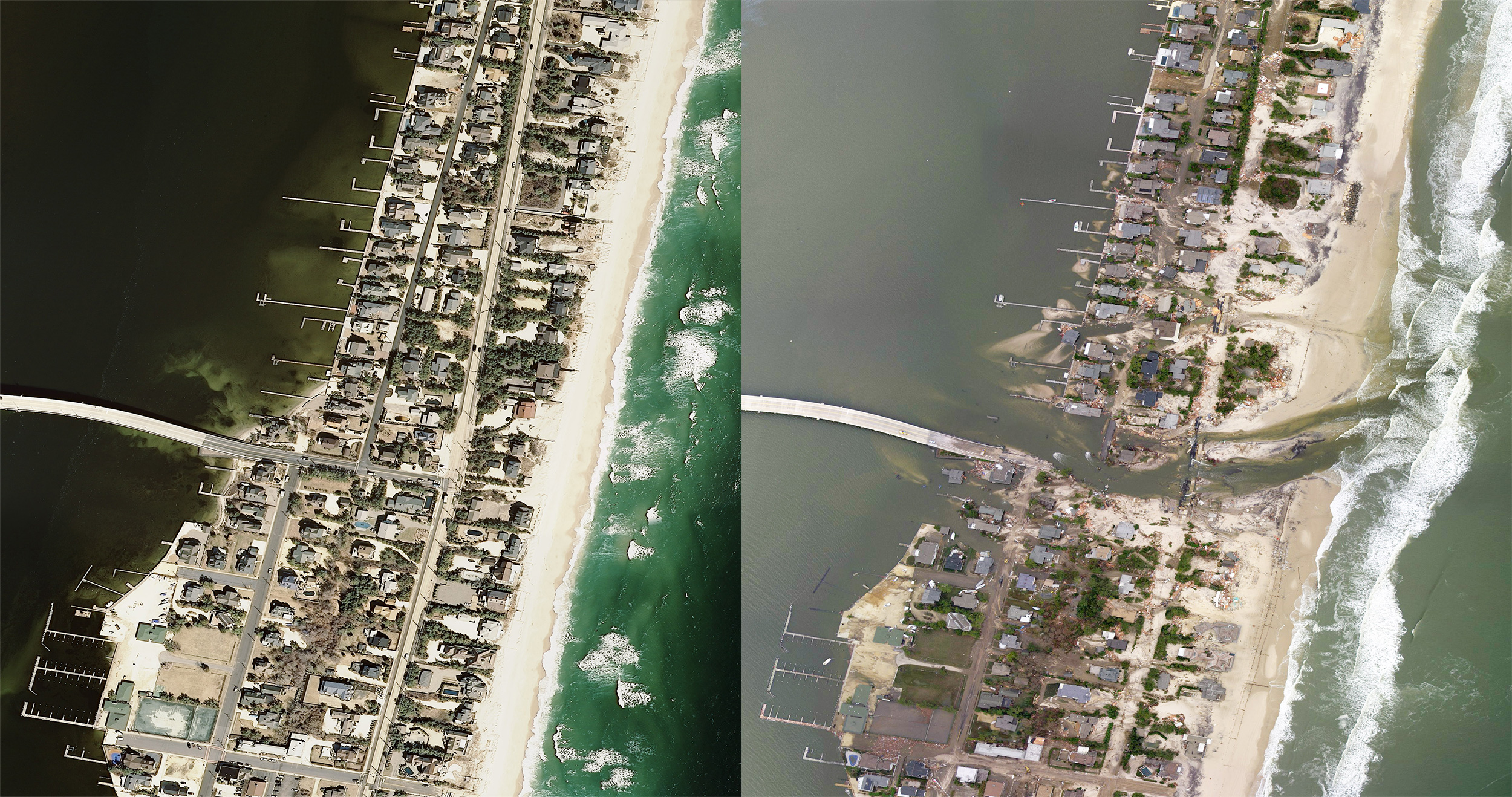
An aerial view of a portion of Mantoloking, before and after the storm surge. Images courtesy of the NOAA Remote Sensing Division
Both towns just happen to lie at weak spots where centuries ago there were naturally formed inlets running from the ocean to Barnegat Bay. Ortley Beach, for example, did not exist in the late 1700s. What is now beachfront was Cranberry Inlet, an important access route for sailing ships heading for the bay during the American Revolution and afterward. Today, both seasonal tourists and most locals know nothing of Cranberry Inlet because around 1815 the currents changed and the inlet silted up, stifling seaborne trade, this despite several costly and ultimately futile attempts by business owners to dredge it out. Manipulating the shoreline is an old habit that dies hard.
Today, the town of Mantoloking is constructing a $40-million sand dune anchored by a 6.5-kilometer-long stretch of buried sheet-steel sea wall that the residents hope will hold back the ocean. And just a few months ago, some 600 Ortley Beach residents joined various community organizations and pressure groups on a protest march from “bay to beach” to demand that the federal government’s engineering branch, the Army Corps of Engineers, finally begin a $100-million project to widen the area’s beaches and rebuild the high protective dunes. Despite strong support from the state, the project remains mired in easement battles with recalcitrant beachfront owners who had purchased their properties to get a great view of the ocean.
Houses once on land awash in the ocean. This picture from Mantoloking is the ground view of the aerial image of above. Photo by Danielle Richards/Demotix/Corbis
And in any case, why should the federal government fund rebuilding these fragile sand castles along the beach—a pricey and hopeless effort? The “soft” remedy of beach sand nourishment is problematic at best.
Over the past 25 years the Army Corps has routinely replenished the New Jersey coastline, dumping some 56 million cubic meters of sand—the volume equivalent to about 22 Great Pyramids of Giza—along 85 kilometers of shore in an attempt to stave off the Atlantic Ocean. “But that’s only temporary; it’ll get washed away,” Pilkey says. “What do we have, 3,000 miles [4,800 kilometers] of barrier island shoreline on the North American coast? We can’t nourish them all to somehow try to keep them all in place.” There aren’t the resources.
Many people believe sand dunes are the answer to saving barrier islands. Dunes have value, Psuty says, “but all too often they’re given the role of savior, which they are not. In reality, the dunes are there because sand is being transferred inland.”
Even in Mantoloking, with its reinforced dune, there’s a high probability of failure. Why? Development. “That first row of prime properties typically force the dunes to be rebuilt too close to the water to ever last in the waves,” Psuty says. Even a big dune with a long steel sea wall within it is vulnerable because it’s placed where it’s inherently unstable. Psuty thinks that the surf will probably start undermining the sea wall in a few years, tops.
In recent years the Army Corps seemingly has recognized the drawbacks (and futility) of both hard structures and soft beach nourishment, and has bet that some shorelines, particularly on the bay side of the barrier islands, can best be defended by so-called living shorelines, featuring restored wetlands, submerged plants, and oyster reefs. One researcher calls living shorelines a “travesty,” while another likens the approach to “putting green lipstick on a pig.” Some others reluctantly note that the concept, which for the first time at least considers the welfare of the natural ecosystem, constitutes something of a step forward.
Part of the answer, it would seem, is to somehow convey an unpopular reminder to residents perched on the edge of disaster, but who hold the topic taboo. David N. Kinsey, an urban/regional environmental planner based in Princeton, NJ, has an idea of how to boost the awareness of local residents about the abiding threat of storm flooding; he suggests “marking the high-water levels on the telephone poles and buildings all over the place, up and down the street. That should help remind them.”

The federal government promotes efforts to rebuild sand dunes on the Jersey Shore, but many scientists say their value is overstated. Photo by Jude Isabella
And why not? In Marin County, California, the Federal Emergency Management Agency collaborated with the county, a tech start-up, and a non-profit environmental organization to install virtual reality viewfinders that show panoramic images of how sea level rise would alter the area. Passersby can look into the devices and see flood images overlying the surrounding scenery.
Whether state-sanctioned graffiti or virtual reality viewfinders will work or not, the notion is reminiscent of the stone high water markers that Japanese tsunami survivors placed along the Fukushima coastline several hundred years ago. Each in its own way admonishes people to remember the calamity of the great tsunamis; do not build any homes below this point. But the modern inhabitants had long ignored the old markers, so when the big underwater earthquake hit the coast in 2011, 12,000 people were swept away in mere minutes.
Although the peril to the Jersey Shore is much less dire, the storm surge threat to the East Coast is sufficiently severe that last year the US Department of Housing and Urban Development asked experts to spotlight novel ways to fend off the next big storm. One idea was to build artificial barrier islands—of sand and stone—to further protect the coast, a testament to humanity’s dueling natures: perseverance versus stubbornness.
Jersey Shore dwellers must know that, in truth, they surf the crest of a colossal swell of wind-blown sand that is being swept slowly and surely inland. And just like any wave, this westerly one will ultimately break and disappear.
Correction: Some wording has been slightly modified from the original published version to reflect newer data released by US government researchers.