
Warning! Signs Are Not Enough to Save Beachgoers from Deadly Currents
Keeping people out of rip currents is more about reading human behavior than reading warning signs.
Article body copy
On a sweltering day in July 2019, Summer Locknick plodded along Prince Edward Island’s Cavendish Beach among hundreds of people lounging on the red-tinted sand. The air smelled of sunscreen as the visitors worked on their tans, blew up inflatable rafts, and cooled off in the sea. Locknick, however, was not there to relax. With a GPS unit and a tablet in hand, she circulated in the crowd, asking people if they knew about an often-overlooked threat slinking through the surf.
Rip currents are one of the deadliest hazards along the coast, yet beachgoers rarely pause to consider them before heading into the water. “Most people who go to a beach aren’t aware of what a rip current is,” Locknick says. These belts of seawater, often wider than a four-lane highway, cut through the surf and flow away from the shore, pulling unsuspecting bathers beyond their depth. Rips, as they’re known colloquially, can occur on any beach with breaking waves—even on the shores of North America’s Great Lakes—and have been measured to flow as fast as a raging river, including some whitewater sections of the Colorado River. Struggling against a rip current leads to exhaustion for even the strongest swimmers.
Worldwide, rips cause hundreds of drownings and necessitate tens of thousands of rescues every year. In Australia, where 85 percent of the population lives within an hour’s drive of the coast, rips cause more fatalities than floods, cyclones, and shark attacks combined. In 1938, one of the country’s most popular beaches, Sydney’s Bondi Beach, was the site of an infamous rip-current tragedy: within minutes, roughly 200 swimmers were swept away by a rip, leaving 35 people unconscious and five dead. More often, however, rips take one life at a time, garnering little media attention. For many casual beach visitors, the toll of rip currents goes unnoticed.
Locknick had only vaguely heard about rips as an undergraduate student at the University of Windsor in Ontario. During a stint as a research assistant in a coastal geomorphology lab, she grew increasingly intrigued by the currents and the reasons people get caught in them. During her graduate studies in 2019, she surveyed 500 people at Cavendish Beach and nearby Brackley Beach to learn how beachgoers perceive the hazard in Prince Edward Island, a province where rips have caused several drownings in recent years. Although almost three-quarters of beach users said they knew what a rip current is, only 54 percent could correctly define it. In addition, only half of the people she surveyed remembered seeing either the warning signs or the colored flags denoting surf conditions that were posted on or near the main access point to each beach. An even smaller percentage could recall what color the flags had been—green for calm, yellow for moderate, or red for dangerous conditions. “I was genuinely shocked,” Locknick says.
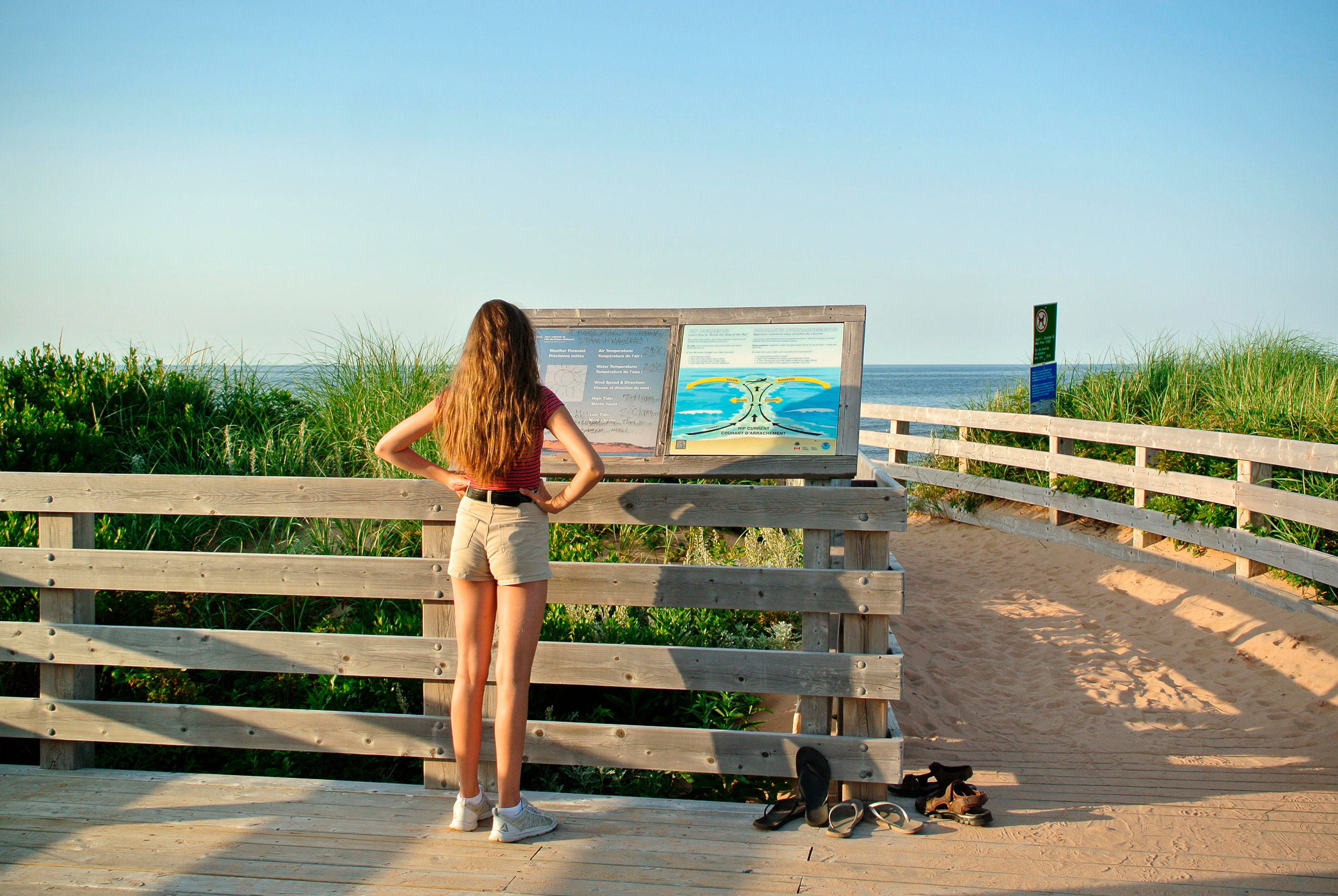
A girl studies an informational sign about rip currents in Greenwich National Park on Prince Edward Island. Photo by Agamat/Alamy Stock Photo
Chris Houser, a professor in the department of earth and environmental sciences at the University of Windsor, who oversaw the work, has seen the same trend throughout his research. Houser started his academic career studying the physical processes that shape the coast but has since branched out to explore the human side of beach safety. While living in the United States in the late 2000s, he began examining public perceptions of rip currents and warning signs, later expanding his work to Australia and Costa Rica, where he has collaborators, and, most recently, to Canada. Many people disregard, misunderstand, or fail to notice warning signs, he says. And sometimes signs are misleading. A major pitfall in many communities’ attempts to save lives from rips is assuming that the warnings work. “You can have the signs, you can have the flags,” Houser says, “but they’re not going to fix the problem.”
Deciding what to put on a sign is not straightforward either: rips are varied, complex features, and a single piece of advice doesn’t guarantee survival. Saving people from rips, researchers have realized, calls for an approach that is much more strategic than posting signs. It requires understanding what leads to rip-risky decisions in the first place.
Part of the challenge of preventing rip-related drownings stems from the lack of a simple method to escape them.
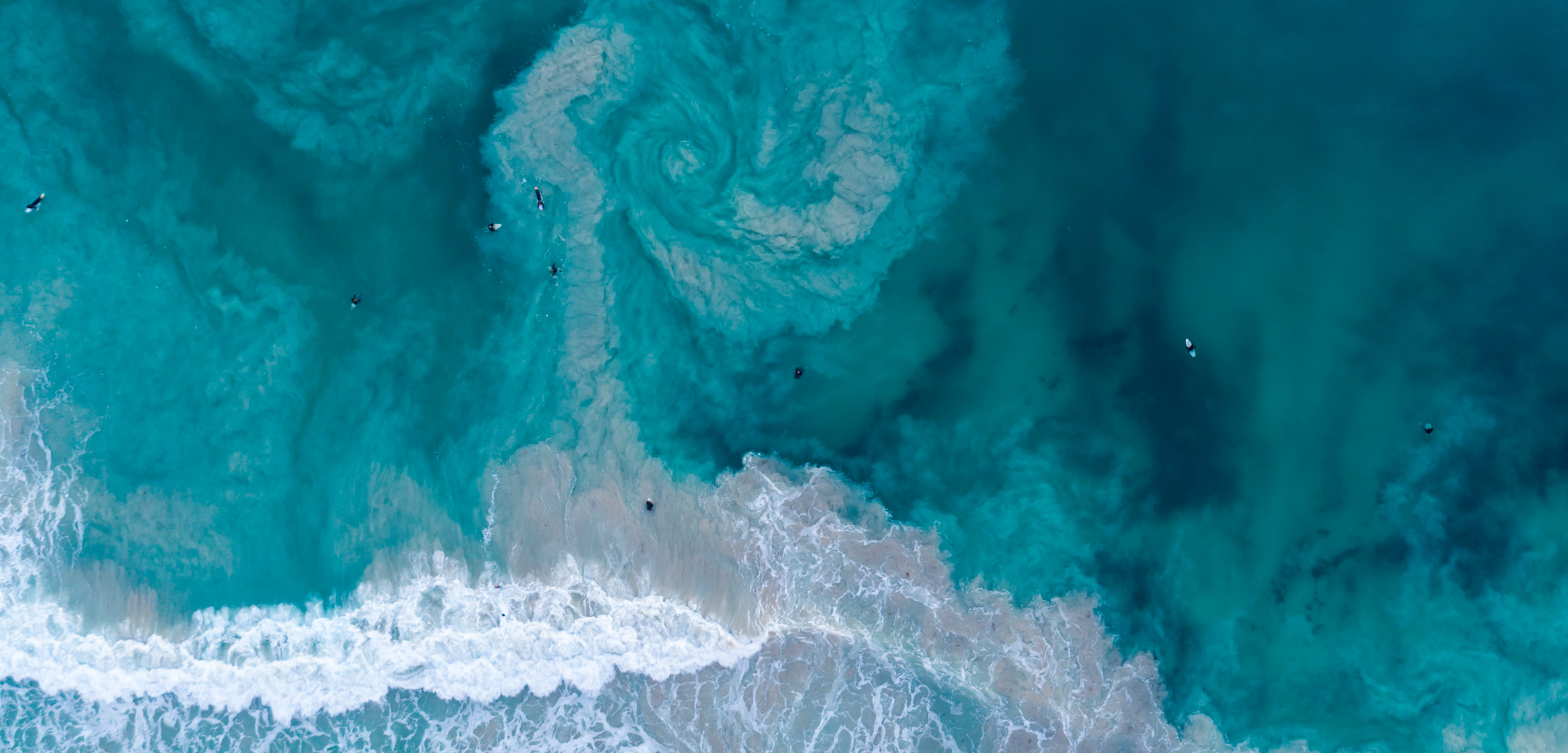
Rip currents form when waves pile water near the shoreline. The water then gushes back out to sea, taking the path of least resistance. It might flow along channels carved in between sandbars or next to solid structures, such as jetties or rocky headlands. These types of rips can stick around year after year. Others are more erratic, creating fleeting bursts of seaward-flowing water on smooth, open beaches. People often mislabel rip currents as undertows or rip tides. Rip currents are not caused by tides, however, and undertows are a different, weaker current, formed when water pushed onto the beach moves back offshore along the seabed. Some telltale signs of a rip include a streak of churned-up, sandy water or a dark, flat gap between breaking waves.
Learn how to spot a rip current with this video from Surf Life Saving Australia.
It’s not surprising that rip currents are often misunderstood by the public because, for decades, beach-safety experts also had an oversimplified perception of their mechanics. In some of the earliest research on rips in the mid-20th century, American scientists watched sticks, pieces of kelp, and volleyballs float out to sea and described lanes of flowing water extending more than 300 meters offshore. This work formed the basis for the popular view of rip currents as jets flowing perpendicular to the beach, shooting out past the surf. To escape the river of current, experts recommended that bathers swim parallel to the beach—a message once broadcast through education campaigns and warning signs in the United States and Australia. As it turns out, that approach may not always work.
In 2010, researchers using floating GPS units to track the trajectory of rips found that the currents often flow in circles, like big eddies. By swimming parallel to shore, people may inadvertently end up struggling against an oncoming current, says Jamie MacMahan, professor of oceanography at the Naval Postgraduate School in California, who led the research. Only about 10 percent of the GPS units he and his colleagues threw into rips were swept beyond the breaking waves. If a swimmer were to simply float and ride a rip’s circular path back toward shore, they may be returned to safety.

Safety experts long thought that rip currents followed a straight shot out to sea, but more recent research shows that some rips have a more circular flow. Photo by Mark Holtzman/ZUMA Press, Inc./Alamy Stock Photo
MacMahan’s findings caused controversy among beach-safety experts, says Robert Brander, a professor in biological, earth, and environmental sciences at the University of New South Wales in Sydney, Australia. To learn what strategy works best, Brander and MacMahan had swimmers test both tactics in various rips around Sydney.
Their research shows that neither strategy is foolproof. “There’s not one single piece of advice in terms of floating or swimming parallel that is guaranteed to work in every rip current,” Brander says. Swimmers should stay calm and may need to consistently reassess their chosen strategy and switch to another if they find it isn’t working. But making such rational decisions goes against instinct. Through interviews with rip-current survivors, Brander learned that most people panic and try to swim straight back to shore, against the current. Any advice they may have heard about escaping becomes useless when fear takes hold.
Rip current survival is clearly more complicated than safety experts long thought. As a result, they shifted focus: educating people on how to avoid the hazard altogether.
In the summer of 2008, a couple lugged a cooler, folding chairs, and a beach umbrella along a white-sand beach in Pensacola, Florida, looking for a place for their two preschool-aged children to swim. They plopped their gear in front of what looked like the perfect spot: a calm ribbon of turquoise water surrounded by shin-high waves. As the children began splashing in the sea, Houser rushed over. The scientist had been studying the movement of sediments along the beach when he noticed the family heading toward what seemed to him like a clearly dangerous spot. Couldn’t they see the rip current? he asked the couple. Hadn’t they seen the signs?
Although the family had noticed the signs posted along the beach, they still hadn’t spotted the rip. To understand what had gone wrong, Houser realized that he had to look beyond coastlines and currents. He had to study people.
The signs posted at Pensacola Beach, created as part of the US National Oceanic and Atmospheric Administration’s (NOAA) nationwide Break the Grip of the Rip campaign, showed an illustration of a rip. In the drawing, the rip was pale blue and the beach curved out. In reality, a rip current often appears darker than the surrounding surf and can give a beach more of a U-shape, including at Pensacola. The signs also portrayed a rip from above, not from the viewpoint of a person standing on the beach. “What a real rip looked like was totally different,” Houser says.
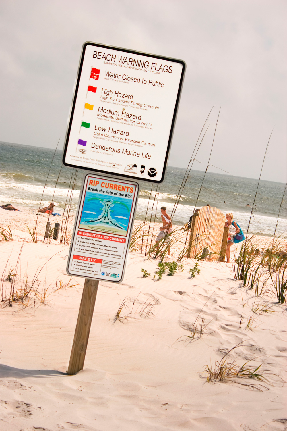
Signs have proved inadequate for keeping beachgoers safe from rip currents. Photo by Ninette Maumus/Alamy Stock Photo
The NOAA sign was only intended to tell people to get out of a rip by swimming parallel to shore, but Houser and his colleagues learned that beachgoers were using the poorly designed sign as a guide on how to spot one. Nearly half of the people the researchers surveyed at three beaches in Texas thought the same NOAA sign was “helpful” or “very helpful” for identifying a rip. The majority of those people couldn’t spot a rip when they were later presented with photographs of the beach, however. Because beachgoers were misinterpreting the sign, they were looking for the wrong visual cues, Houser says.
Even when beachgoers know what to look for, rip currents are difficult for the average person to see. And people tend to ignore warnings when they don’t align with their own perceptions, Houser says. When waves are small, for example, people assume the water is safe, even though rips may still pose a hazard. From 2004 to 2008, more than 60 percent of all surf rescues at Pensacola Beach occurred on days when lifeguards assessed conditions to be more dangerous than they appeared to the average person.
The presence of others and past experiences at the beach can also sway judgment. When beachgoers see others enjoying the water, they are inclined to believe conditions are safer than they are. And if people who decide to enter the water despite warnings are lucky enough to avoid getting caught in a current, they may think warnings are overblown.
Plus, by the time people’s feet hit the sand, the vast majority aren’t even thinking about safety, says Brander. “They’re just thinking about having a good time.”
To get ahead of some of these issues, several countries have adopted campaigns that aim to educate people about rips before they get to the beach, when they are in a more receptive frame of mind. In Australia, safety experts have disseminated information through ads at bus stations and airports and on social media. Brander has also released harmless purple dye into rips, with footage of the dramatic streaks appearing on TV and online videos. The effectiveness of these interventions is only beginning to come to light, with some research suggesting they can improve public understanding of the hazard. In Canada, where beach safety has been slower to develop, efforts to educate people about rip currents are only starting.
On the rugged west coast of British Columbia’s Vancouver Island, a 16-kilometer stretch of sand is one of Canada’s most popular beach destinations. Located in Pacific Rim National Park Reserve, Long Beach runs between the communities of Tofino and Ucluelet, and on the beach’s north end, a green-capped mound roughly the size of a Manhattan city block protrudes from the surf. The islet, known as Lovekin Rock, is accessible by foot on the lowest of tides, enticing visitors to reach its flanks. When the tide sweeps in, however, the rock forms a rip current that can catch walkers off guard.
“It’s a notorious location,” says Karla Robison, an avid surfer and environmental and emergency safety specialist based in Ucluelet. In 2019, Robison was using the rip that hugs Lovekin Rock to paddle out for a surf when she noticed someone in the water, clinging to the side of the islet. Robison pulled out of the current into a still section in front of the rock. As she reached the man, she saw that he was blank-faced and pale. He also wasn’t wearing a wetsuit, which can be dangerous in the region’s frigid water. Whether from cold or fear, he was frozen, she says.
Robison helped the man onto her board and, along with another surfer, towed him back to shore. Later, she learned that he had been walking out to the rock with his son when the tide came in. While the son fought his way back to the beach, the growing current swept the father into deeper water, until he was stopped by the rock. The situation could have been worse, Robison says. In recent years, several people have drowned in the same area.
The infamous rip around Lovekin Rock near Tofino, British Columbia, has pulled many swimmers and walkers beyond their depth. Photo by Maria Janicki/Alamy Stock Photo
The rip around Lovekin Rock is a prime example of how swiftly rip currents can change. Scientists have found that rips are not only influenced by tides, but also by various environmental factors, such as the size of the swell and the location of shifting sandbars, which make forecasting rips difficult. The strength of a rip is only one aspect of its danger, however—a more important predictor of how deadly a rip may be is the number of people in and around it.
In Pacific Rim National Park Reserve, safety experts are grappling with the issue of growing crowds combined with limited public awareness of coastal hazards, including rips, unexpected waves, and cold water. Randy Mercer, a park visitor safety technician, was struck by the problem on a tempestuous day about 10 years ago. He was trying to warn beachgoers that waves pummeling the shore could roll beached logs or knock people off their feet, but he couldn’t keep up with the hordes of storm watchers pulling into the parking lot. Since then, visitation to the region has only increased. In 2019, more than one million people visited the park—nearly 50 percent more than in 2011. “Every year is a record year,” Mercer says. Local authorities don’t have a standardized approach for tracking rip-related occurrences, but Parks Canada responded to 82 marine and coastal incidents near Lovekin Rock between 2004 and 2015.
To enhance public safety, Mercer led a collaboration between Parks Canada and the Districts of Tofino and Ucluelet, with input from tourism groups and the Tla-o-qui-aht and Yuu-thlu-ilth-aht First Nations, among others. In 2017, the team launched a campaign, called CoastSmart, to educate visitors about coastal hazards. Mercer, Robison, and their colleagues standardized warnings at beach-access points, but knowing that signs alone aren’t enough, they also emulated education campaigns abroad, such as those in Australia.
This video produced under the CoastSmart campaign provides a view of a rip from a surfer’s perspective.
Visitors may now encounter safety information on brochures, LED highway signs, and an interactive website. Local businesses, such as hotels and surf shops, also share information in person and online. The goal is to reach people at multiple stages throughout their trip, starting from the point they start planning a visit, Mercer says. This increases the chances of getting information across, and compared with signs, face-to-face interactions are more likely to get people to change their behavior, he says. In that vein, local ambassadors, such as artists, educators, and professional athletes, use their social influence to help spread public safety messages. Recently, the CoastSmart team also developed a map of persistent rip currents in the area to help visitors avoid them.
The program has increased the consistency of safety messages, says Keith Orchiston, the District of Tofino’s emergency program coordinator, who helped develop CoastSmart. Without consistent reporting, however, it’s unclear whether the program has actually reduced the number of incidents. Robison believes rip-related occurrences are still a problem, and because the region has no surfguards to carry out rescues at the beach, the responsibility often falls to locals.
Surfguards are one of the few proven means of preventing drownings, Houser says, but they can’t be stationed at every beach. Parks Canada ran a surfguard program in Pacific Rim National Park Reserve for about 40 years, but canceled it in 2012. Tofino local Doug Palfrey estimates that during the 36 years he served as a guard, he and his colleagues rescued between six and 20 people each year, largely from the Lovekin Rock rip.
In the absence of surfguards, researchers may be able to harness what they have learned about beachgoers’ decision-making to steer them toward safer choices when they arrive at the coast. People tend to pick a spot to swim based on convenience, and all too often, beach-access points unintentionally funnel people toward persistent rips.
At Sydney’s Bondi Beach, a busy bus stop and several hostels happen to be positioned close to a rip current fittingly called Backpackers’ Express on the beach’s southern end. Tourists get off the bus, drop their bags, and head straight into the water, Houser says. By engineering beach-access points, safety experts could guide people to swim in safer locations. Existing rip-current forecasts also tend to cover large areas and often do not factor in a beach’s underlying morphology, which limit their value for any specific beach, Houser says. Accurate, localized forecasts could help beachgoers make better decisions.
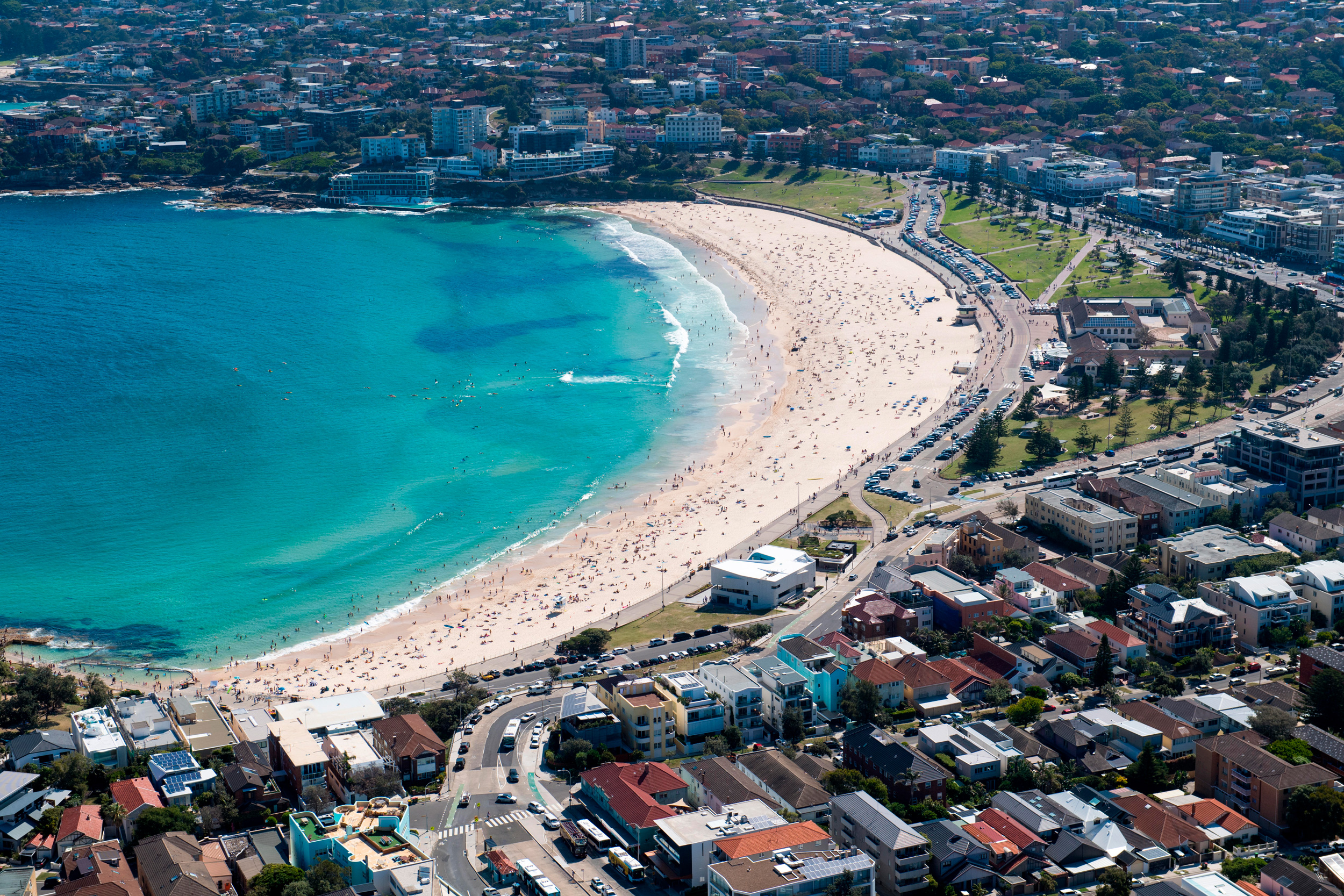
Visitors to Bondi Beach in Sydney, Australia, are often surprised by a rip known as Backpackers’ Express. Photo by mjmediabox/Alamy Stock Photo
Houser will soon put these ideas to the test. In March, he secured funding to create a real-time, localized warning system at Station Beach, a sandy shoreline along Lake Huron in Kincardine, Ontario, that abuts a jetty, where a rip often forms. Over the next three years, Houser and his colleagues plan to develop a hazard rating that is true to conditions at various spots on the beach. A set of traffic lights at each access point will warn of low-, moderate-, or high-risk conditions, and an app will provide suggestions on where to swim. Houser and his colleagues also intend to track pedestrian traffic to inform a beach-access redesign, ensuring people are guided away from the rip current.
If the project is successful, similar tactics could be implemented at other beaches, including along coasts, Houser says. But he is cautious about getting ahead of himself. Researchers now understand many of the human factors that undermine rip-current safety, but overcoming them is a whole other challenge.