
Okay Google, Let’s Map Some Mud
A massive new map of the world’s mudflats may help save critical shorebird habitat.
Article body copy
Between 1984 and 2016, about 16 percent of the world’s mudflats disappeared, according to a new data set from Australian researchers. That’s bad news for endangered tidal ecosystems. It’s also terrible news for the world’s dwindling populations of migratory shorebirds that use the flats to load up on calories and essential nutrients during their annual migrations.
Study coauthor Nick Murray likens the problem of dwindling mudflats to someone driving a car from New York to Los Angeles and finding closed gas stations or those with insufficient fuel along the way. “If you can’t get enough fuel, eventually you can’t make it,” he says.
Coastal mudflats are tricky to map individually let alone en masse, in part because they are ephemeral. They’re here at low tide and gone at high tide. To create this extraordinary data set, published this week in Nature, the researchers pulled images from the Landsat satellites from 1984 to 2016. They developed an algorithm to distinguish the extent of mudflats at low tide and calculate the change in area over the 32-year period. But though the calculation was fairly straightforward, the sheer volume of data involved was huge. Murray realized that running the algorithm on 700,000 high-definition images needed immense computing power.
To calculate the global loss of this ecosystem, Murray and his coauthors partnered with Google and used the company’s Cloud computing power to run the algorithm. “It took about 25 days,” says Murray. “If I started that on my laptop, I’d expect it to return the result in about 100 years.”
The result, with about 80 percent accuracy, showed that while some tidal mudflats grew, many shrank, with a net loss in area of 16 percent. The biggest mud thieves in the images analyzed were coastal developments, shoreline hardening projects, dams that prevent enriching sediments from flowing to the coast, and sea level rise.
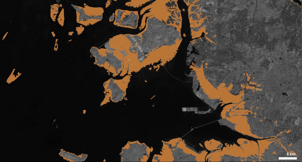
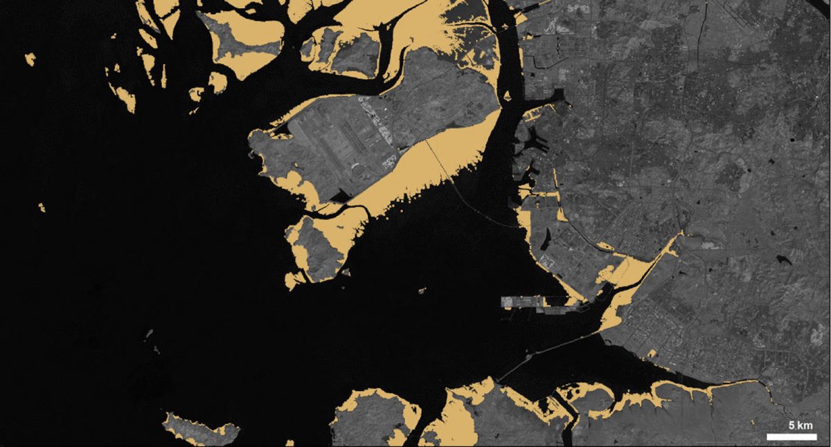
These maps from 1984 and 2016 show the loss of mudflats due to the construction of the Songdo International Business District and the Incheon International Airport in South Korea. Over 600 hectares of tidal flats were reclaimed by the developments. Landsat imagery courtesy of NASA Goddard Space Flight Center and US Geological Survey
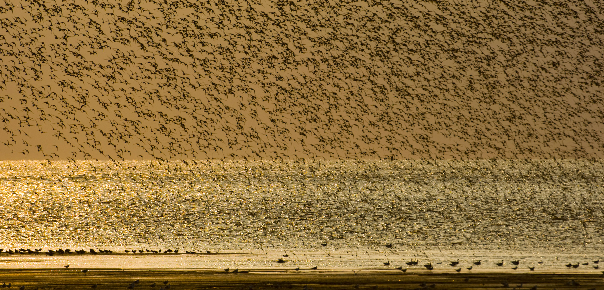
The loss of mudflats to development may be one reason shorebirds are declining. One report says shorebirds in North America have declined by 70 percent since the 1970s.
Tidal mudflats protect shorelines from erosion and storm surges, plus they’re critical habitat for shorebirds. They comprise flyways, known chains of stopovers for birds on their seasonal long hauls. The Pacific Flyway in North America, for example, is made up of nearly a dozen mudflats between Panama and Alaska and sees millions of birds from dozens of species pass through each year in massive flocks.
“The productivity of these flats is really high,” says Yvonne Verkuil, chair of the International Wader Study Group at the University of Groningen in the Netherlands, who was not part of the study. Verkuil says food availability on mudflats is more predictable than most inland habitats because tides regularly deposit nutrients. Shorebirds have even adapted to eat a variety of mudflat offerings like arthropods, worms, and biofilm. Many shorebirds have specialized beaks, gizzards, and tongues that let them eat quickly and easily off mudflats and would find it impossible to feed in any other habitat.
Verkuil hopes this work brings attention to an underappreciated ecosystem. “It’s not something that necessarily speaks to people,” she says of mudflats’ oozing, inaccessible, and aesthetically challenging expanses. But their loss is a problem. “It’s one of the most endangered habitats in the world, but it’s so invisible. And this study makes it visible.”
Murray is doing more than making it visible. He and his coauthors are making the data set and algorithm freely available to researchers in hopes that scientists around the world will access the data relevant to the areas they’re studying. Communities are more likely to limit development or to seek mudflat-friendly ways to build on the coast if there’s data on their local conditions available, Murray says, although he acknowledges that further impacts are likely inevitable.
The world’s population is growing, and this growth is disproportionately skewed to coastal regions. “There’s such huge migration to coastlines, especially in East Asia,” Murray says, adding that if we can learn how the built environment along coastlines impacted the local mudflats in the past, maybe we can engineer better solutions for the future.