
Buried History
Off the coast of Florida, archaeologists are finding ancient sites hidden beneath the waves, tucked into the state’s sunken continental shelf.
Article body copy
The following excerpt is from writer Laura Trethewey’s latest book, The Deepest Map: The High-Stakes Race to Chart the World’s Oceans, which tracks the global effort to map the seafloor by 2030. Trethewey has written for Hakai Magazine since 2016. For her magazine stories, Trethewey has learned how to weave baskets, salvaged fish from drying riverbeds, and waded into the mysterious world of sturgeon.
X marked the spot. We were close.
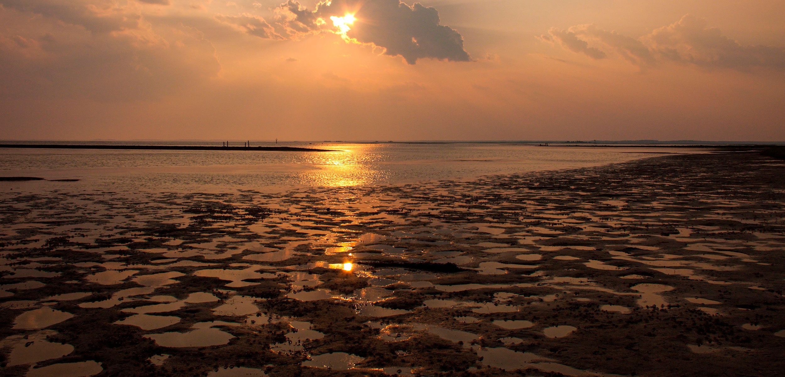
That morning, a crew of diving archaeologists boarded a boat in the town of St. Marks, Florida, and steamed out to the Gulf of Mexico. As the sun rose and the morning fog lifted, the pontoon boat followed the winding St. Marks River through the mangroves. Alligators’ eyes sank into the brackish water as the boat chugged past, noisy herons took flight. On our right, we passed Fort San Marcos de Apalache, built by the Spanish in the 17th century at the confluence of the St. Marks and Wakulla Rivers. Over the centuries, the fort was burned, rebuilt, looted by pirates, occupied by the British, retaken by the Spanish, and later seized by Andrew Jackson, the seventh president of the United States. What had once been a commanding fortress, hurricanes and history had eroded into an overgrown spit of jungle lined by boulders. Here and there, tall copses of pines and pond cypresses rose above the swamp; each one was likely an archaeological site with an oyster midden hidden at its base. This is the “real” Florida, as locals here in the Big Bend like to say, far from the glitz and glamor of Miami but rich in history.
I first met the archaeologists in the summer of 2021. Shawn Joy, with Florida’s Department of Historical Resources, and his collaborator Morgan Smith, an assistant professor at the University of Tennessee at Chattanooga, had just finished mapping portions of Florida’s Apalachee Bay in the Gulf of Mexico, where they turned up nearly two dozen potential sites from the Late Archaic period (5,000 to 2,500 years ago).
Archaeology under the water typically turns people’s thoughts to shipwrecks. But Joy and Smith are doing something much more difficult: searching for and locating precontact sites buried on Florida’s sunken continental shelf.
The archaeologists find it hard to communicate just how much history is still out there buried on the continental shelf. Around 40 percent of the world’s population today lives within 100 kilometers of a coastline. In Florida, that statistic is nearly double, with 76 percent of its population, or around 15 million people, living by the coast. Throughout antiquity, people have always been drawn to water, whether a river, a sinkhole, or a coastline. “Put people on the coast, and watch the life just rev up: hunting, gathering, art, culture …” said Joy. “Get people inland, and it’s like, Well, shit, how am I going to live today?” He gave a rough Neanderthal shrug. If even a fraction of early Floridians liked the ocean as much as present-day ones do, there’s a whole world of human history waiting there to be uncovered. And the farther offshore you go, the farther back in time you travel.
Up ahead, a postcard-perfect white lighthouse announced our entry into the Apalachee Bay. It was a calm day on the Gulf, not a ripple brushing the flat, limpid surface. Two weeks earlier, Joy and Smith had spent all night here on Joy’s sailboat, running a sub-bottom profiler—a sonar similar to the one I had heard quacking against the steel hull of the E/V Nautilus—back and forth over the bottom. They had “mowed the lawn” that night, going back and forth, back and forth in search of underwater sites. The sites they had found, 18 in all, were sprinkled across Joy’s GPS screen as he steered the boat. Over the coming days, we were hoping to dive them all.
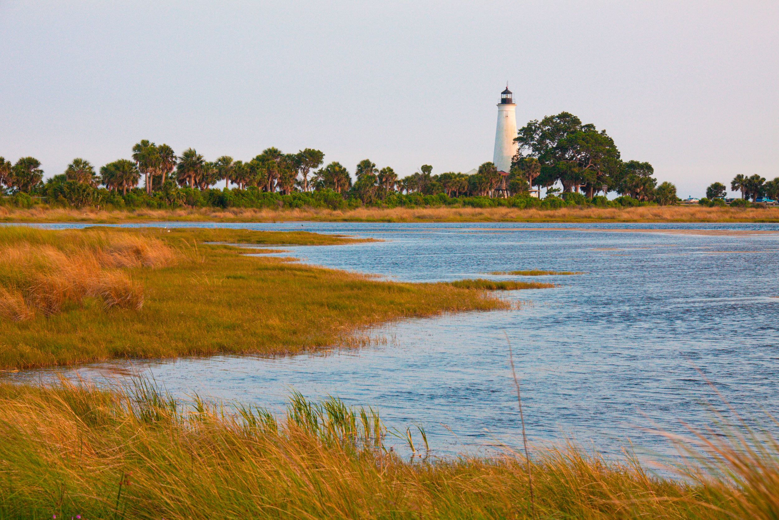
The postcard-perfect St. Mark’s lighthouse marks the entry into the Apalachee Bay. Photo by Frank Tozier/Alamy Stock Photo
“Twenty-five meters,” Joy called from the helm. We were over three kilometers offshore now and closing in on the first site. Joy killed the engine. For a few silent moments, the boat coasted on momentum. I leaned out over the gunwale, looking down through shallow green water. Rays of sunlight lit up the swirling underwater pastures of bright-green eelgrass, big stumps of coral, rippled sand dunes dotted with pretty white scallop shells.
“Ten meters,” Joy called, watching the GPS from behind neon-green shades.
“What side?” Smith called back excitedly. He was standing on the bow, ready to fling the anchor he held in his arms as soon as Joy gave the word.
“Port,” called Joy. Smith moved to the left side of the boat. All of us on board—Smith, Joy, a volunteer diver named Ximena, and I—peered into the water, searching for a sign of the site. Sand, eelgrass, coral: it looked the same as everything else we had passed.
An odd shape in the soundings of a sub-bottom profiler had brought us to the spot. A sub-bottom profiler typically scans the sediment of the seabed, hence the “sub-bottom” in the name. The results look a little like a drippy layer cake in grayscale, each layer representing a different slice of sediment. Oil and gas surveyors use sub-bottom profiling to find untapped reserves; ocean mappers use it to spot buried cables or locate sturdy terrain on which to build bridges. Why not use it to try to find ancient stone artifacts, too? Well, archaeologists had tried that before, with little success. In 1982, the world-famous Danish bassist Hugo Rasmussen took stone flakes and blades to a sound laboratory. In a series of experiments, he found that each artifact produced a specific tone when blasted with sound frequencies. Experts reasoned that it should be possible to track down underwater sites using sound, except they couldn’t quite figure out how to do it.
In 2014, a team of archaeologists and geophysicists from Israel and Scandinavia joined forces to see whether sub-bottom profiling might be the missing key. Running field experiments at two confirmed underwater sites in Israel and Denmark, they discovered odd shapes in the sub-bottom soundings. The shapes were hovering in the water column, fat at the top, tapered at the bottom, and looked a little like haystacks, so that was what they called them. The haystacks didn’t move, so they weren’t a school of fish, and they were found floating right above stone artifacts buried in the seafloor. It turned out that the sub-bottom profiler could reveal underwater archaeological sites, but the experts were looking for signs in the seabed where they expected to find the artifacts rather than in the water above.
We often perceive people who fashioned tools out of stones as primitive, but the tools tell a different story. They had a sophisticated appreciation of stone and sound, carefully selecting the right material for arrowheads or knives by tapping the stone first to see whether it made the correct sound. The right tone told the early toolmaker that the stone was free of flaws and fissures: a quality piece that would hold up long after he moved on from the quarry. The aural quality of that stone is a clue left behind for ocean-mapping archaeologists thousands of years later. Here in Florida, Smith and Joy were using the technique, now known as the Human-Altered Lithic Detection method, to lead them directly to ancient sites sunken on the seabed across the northeastern Gulf of Mexico.
“Huck it! Huck it!” yelled Joy. Smith sent the anchor flying as far from the boat as possible. A splash. It sank. The boat ran to the end of the line and then slowed to a gentle stop. Smith, still wearing his khaki shirt and pants, dived in immediately. The sound of water breaking snapped me out of my early-morning daze. Right, of course, this wasn’t a fun boat trip. We were here to dive.
Smith paddled around the boat for a moment, head down, goggles on, scanning the bottom. “Oh, yeah,” he said, raising his head out of the water, sopping bangs plastered to his forehead. “Artifacts everywhere.” He did a jackknife down to the bottom: flippers high in the air followed by a slow slide to the bottom. A moment later, he was back, holding something small in his hands. He pulled his goggles off and studied what was in his hands a little more closely.
“What is it?” I asked eagerly, leaning out over the side of the boat.
It was chert, a prized material among the early stone-working people of the world. By whittling away at a core of chert, the early inhabitants of Florida made a range of notched and pointed blades, scrapers, and choppers in a process known as flint knapping. The flake Smith was holding was the leftover debris. He swam over to the boat and dropped the flake onto my outstretched palm: the first find of the day. The jet-black stone was about the size and shape of a tortilla chip. One edge was a couple of centimeters thick; the piece sloped down to a wafer-thin triangular tip that was almost transparent when I held it up to the dazzling Florida sun.
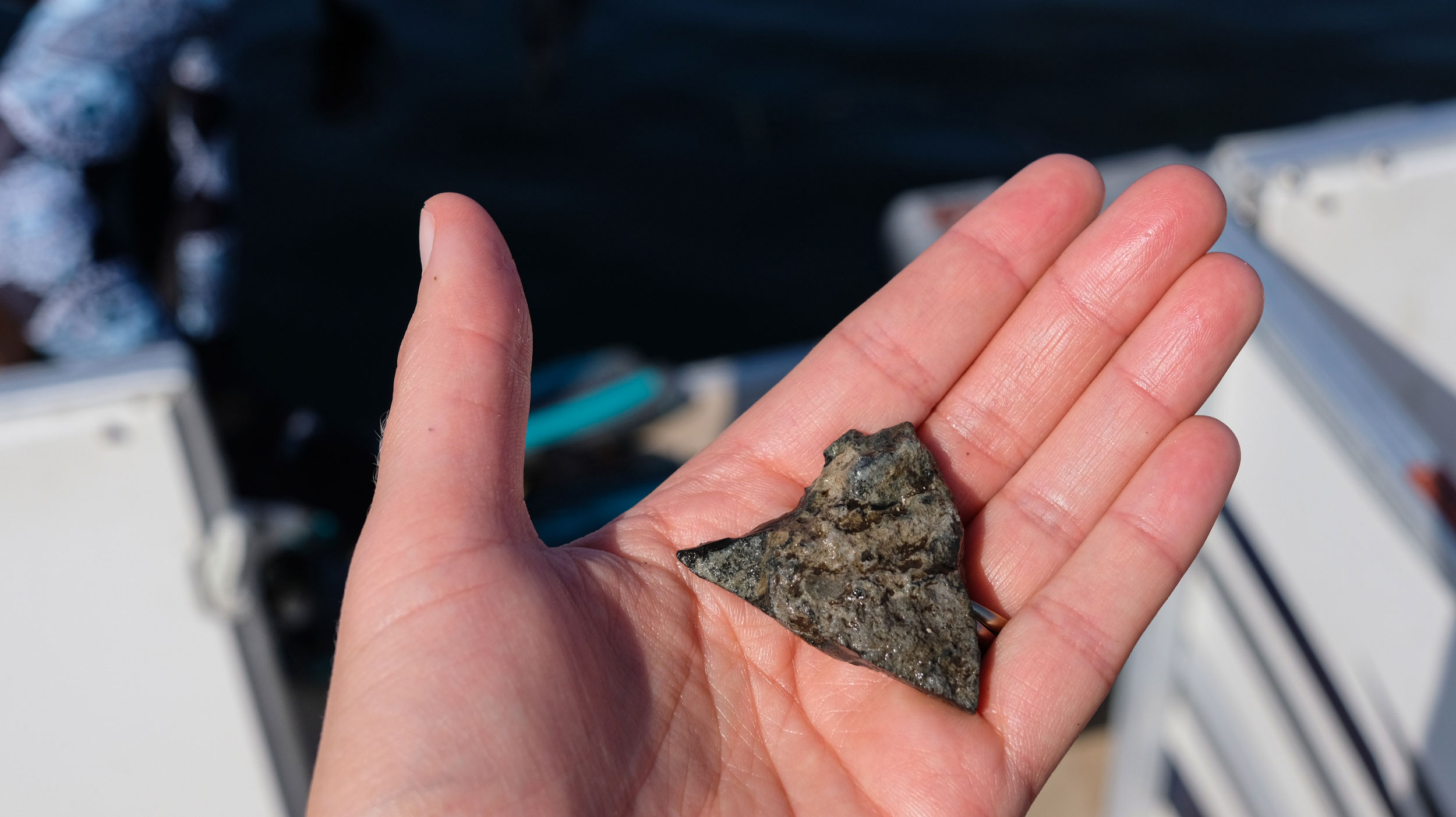
Last touched by someone more than 3,000 years ago, this flake of precontact mining debris was about the size and shape of a tortilla chip. Photo by Laura Trethewey
Apart from Smith, the last time someone had touched that flake had been more than 3,000 years ago. The thought made me shiver. There’s something addictive about being “the first” to see something, touch something, do something that no one else has ever done. It was the same feeling Victor Vescovo had felt while exploring the Puerto Rico Trench for the first time. The flat seascape at the deepest point of the Atlantic wasn’t what had interested Victor the most; it was the knowledge that he had arrived first. The same urge drives so much exploration, so much filling in of the map. There’s also something possessive about claiming to be “first.” It reminded me of the way phrases such as “virgin territory” make me squirm.
Of course, it wasn’t as though I were Howard Carter, peering into King Tut’s tomb. I was holding a rock that looked, to the untrained eye, like any other rock. How would I know that this rock had been left by a precontact hunter hacking away at a boulder 3,000 years ago? “Hertzian mechanics,” said Smith. He was hanging off the ladder on the boat’s stern. When a stone is struck, it behaves a certain way, he explained, “like a bullet shattering a pane of glass.” He took the flake from me, ran a finger along the sharp straight side. “This is called a flat form, where the object was struck. And you feel here, right beneath that platform,” he said, pointing to the chunkier part of the stone, “you can feel how the stone expanded there, where it’s bulbous. The only way that happens is by something very hard striking the stone.”
Both Smith and Joy are trained in geoarchaeology, using geological principles and methods to confirm how a site formed, when it might have been abandoned, and why an artifact was deposited there. This deeper understanding of oceanography and marine geology is critical for convincing the skeptics of submerged archaeology. Some coastlines do stir up enough energy to create “geofacts,” flakes that break off naturally. In California, sudden downpours cause parched rivers to swell and burst with enough energy to create geofacts. Archaeologists at the Calico Early Man Site in the Mojave Desert claimed to have found stone artifacts dating back 50,000 years or even earlier, but those findings were later disputed because the rocks had been found in the geological deposits of a fast-moving river. But that is not the case in the Gulf of Mexico, explained Smith. It’s far too sluggish to produce geofacts.
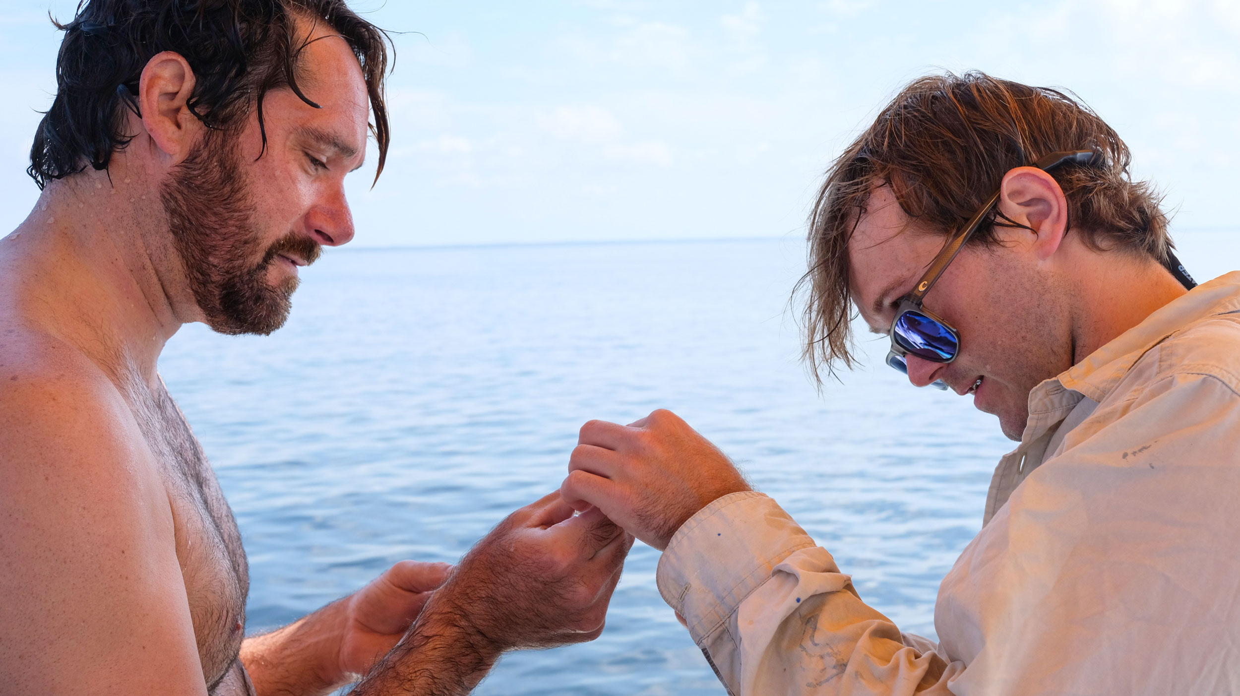
Underwater archaeologists Shawn Joy (left) and Morgan Smith examine a precontact artifact they found by mapping Florida’s Apalachee Bay. Photo by Laura Trethewey
What about hurricanes? I asked. Couldn’t a Category 5 generate enough power to smash stones apart? “When hurricanes hit, oh, it gets nuts out here,” Joy piped up from the helm. During 2018’s Hurricane Michael, the last “big one” in Florida’s Big Bend region, winds and waves had surged into St. Marks, ripping out trees and roads, downing power lines, flooding homes. Surprisingly, the bottom of the Apalachee Bay hadn’t shifted all that much. Joy told me about a site he had dived where he had found two stone flakes sitting next to each other that fit together, what is called “refit,” meaning the two pieces had been hacked off each other. Joy had set the two pieces down on the seabed next to each other, right where he had found them. About a year later, he had returned and found them lying in exactly the same position. “We’re trying to disprove that misconception [against submerged archaeology] by saying, ‘Hey, look, we have integrity here,’” said Joy. “This stuff hasn’t moved all that much since sea levels rose.”
In short: human hands made the stone I was holding. The Apalachee Bay appears to be a drowned quarry site where precontact people worked and lived. “When you find the quarry, now you have an anchor on this landscape. Because rock is really heavy, right? You don’t want to carry it far. So somewhere around here, there should be a base camp,” said Smith. Finding a base camp could lead to discovering a collection of stone tools that could lead to a better understanding of how an ancient people lived. But the starting place was the flake I held in my hands.
 Adapted from The Deepest Map: The High-Stakes Race to Chart the World’s Oceans by Laura Trethewey, to be published by Goose Lane Editions on July 11, 2023. Copyright © 2023 by Laura Trethewey.